The Normans and Great Bradley
In October 1066 the Anglo-Saxon King Harold Godwinson, King of England and former Earl of Suffolk lost the Battle of Hastings to William the Conqueror and the kingdom of England passed from Anglo-Saxon rule to the Normans. The transition to full Norman rule took some 5 years in Great Bradley.
After the battle, Edwin Leofric (Eadwine in Anglo Saxon), the Overlord of most of the lands around Great Bradley (and whose sister had married Harold) returned to Mercia, hoping that William would be content to rule in southern England. When it became clear that he was not, Edwin reluctantly submitted to William at Barking in January 1067. In 1068 Edwin rebelled against William but soon submitted tothe King once again.
In 1071 though, Edwin travelled north to join with Edgar the Aetheling in Scotland with the intention to resist Williams rule (Edgar, a teenager, had been put forward as an Anglo Saxon King after Edward the Confessor’s death in 1066 before the Conquest). On the way to Scotland, Edwin was betrayed by his own men and killed.
The records show that the local lords of the land around Great Bradley (ultimately owned by Edwin) were also displaced in 1071. These were Ulf son of Mani Swart and Wihtgar Aelfricsson and someone called Bondi. It was at this point that his lands in Great Bradley passed from the Anglo-Saxons to the Normans.
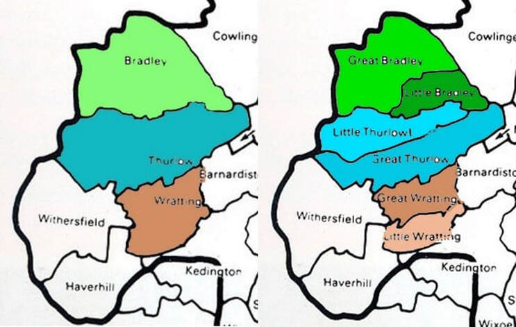
At the time, Great Bradley and Little Bradley were just as one place called Bradley (an Anglo- Saxon word meaning Wide Clearing in a Woodland).
The details of the land owners in Great Bradley are known because the Normans conducted of a survey between 1085 and 1086 of much of England to evaluate the taxes owed to the King. We know this survey as the Domesday Book. Five different land holdings are identified along with their owners, the people and animals on the land and what the taxable value was. A population of 56 households was recorded, putting Bradley - believe it or not - in the top fifth of largest settlements recorded in the Domesday Book. Haverhill had 54 households, Thurlow had 60 and Bury St Edmunds had 207. London had a population of 10,000.
By 1086 the five packets of land in Bradley listed as being under the control of three owners: Bury St Edmunds Abbey and the Normans, Richard Son of Count Gilbert and Richard of Tosny.
In Saxon times, the Abbey in Bury St Edmunds held 2 pieces of land. One had 12 Freemen, 2 smallholders and enough land to be ploughed by 4 men’s teams (of oxen); there was 2 acres of meadows and it was worth 1 pound, 1 shilling and 2 pence. The Abbey was permitted to retain this land after the Norman Conquest.
In Saxon times, the Abbey in Bury St Edmunds held 2 pieces of land. One had 12 Freemen, 2 smallholders and enough land to be ploughed by 4 men’s teams (of oxen); there was 2 acres of meadows and it was worth 1 pound, 1 shilling and 2 pence. The Abbey was permitted to retain this land after the Norman Conquest.

By 1086 the five packets of land in Bradley listed as being under the control of three owners: Bury St Edmunds Abbey and the Normans, Richard Son of Count Gilbert and Richard of Tosny.
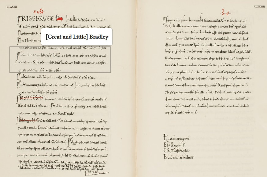
Domesday Book Entry for land that St Edmunds Abbey lost
In Saxon times, the Abbey in Bury St Edmunds held 2 pieces of land. One had 12 Freemen, 2 smallholders and enough land to be ploughed by 4 men’s teams (of oxen); there was 2 acres of meadows and it was worth 1 pound, 1 shilling and 2 pence. The Abbey was permitted to retain this land after the Norman Conquest.
The other piece of land had 2 Freemen, 2 men’s teams of oxen and 2 acres of meadow. It was worth 1 pound 2 shillings and 5 pence. By 1086 it had been granted to Richard son of Count Gilbert
The third piece of land in Bradley had been controlled by the Saxon Wihtgar (son of Aelfric). It had 2 Freemen, 1 men’s team of oxen and 1 acre of meadow. It was worth 17 shillings and 5 pence. This land was also given to Richard son of Count Gilbert.
The fourth piece of land was controlled by someone called Bondi and four Freemen. There were 2 men’s plough teams and 5 acres of meadow. It was worth 1 pound, 2 shillings and 5 pence. This land was also taken over by Richard son of Count Gilbert.
The last piece of land in Bradley was the biggest and most valuable. In Saxon times it was controlled by Ulf (son of Manni Swart). On the land were 14 villagers and 6 slaves, 12 small holders and there were 3 lord's plough team and 7 men's plough teams. There was 13 acres of meadow, woodland with 500 pigs, 1 cob, 18 cattle, 53 pigs, 63 sheep, 7 goats and a beehive. Significantly, there was also a church with 0.12 acres of land. In total the land was worth 8 pounds. This land was given to Robert de Tosny. Tosny is a town, today about the size of Newmarket, between Rouen and Paris is northern France. There is no evidence of a Saxon church in present day Great Bradley so the church mentioned here must be in present day Little Bradley - which even today has evidence of its have Anglo-Saxon origins.
The last piece of land in Bradley was the biggest and most valuable. In Saxon times it was controlled by Ulf (son of Manni Swart). On the land were 14 villagers and 6 slaves, 12 small holders and there were 3 lord's plough team and 7 men's plough teams. There was 13 acres of meadow, woodland with 500 pigs, 1 cob, 18 cattle, 53 pigs, 63 sheep, 7 goats and a beehive. Significantly, there was also a church with 0.12 acres of land. In total the land was worth 8 pounds. This land was given to Robert de Tosny. Tosny is a town, today about the size of Newmarket, between Rouen and Paris is northern France. There is no evidence of a Saxon church in present day Great Bradley so the church mentioned here must be in present day Little Bradley - which even today has evidence of its have Anglo-Saxon origins.
The coming of the Normans not only meant changing ownership of the land but a different way of life. And in the near future, it would be the exchange of land between the new Norman rulers that would bring about the separation Bradley into Great and Little Bradley.
For more information on Bradley and the Domesday book see https://opendomesday.org/place/XX0000/great-and-little-bradley/
When Harold was defeated in 1066 by William the Conqueror, the Normans became the dominant landowners. Many Suffolk leaders had been killed or their land confiscated. The land in Great Bradley was previously controlled by the Saxon/ Danish thane, Ulf.
The land they occupied was about the same as the parish area now. Ulf's manor was described as being 1 league long by 7 furlongs wide (approx 21/2 miles by 7/8 mile). It is probable that the first Norman ruler was Robert of Tosny. Robert's land was recorded in the Domesday Book of 1086 a covering 7 carucates (the amount of land 7 teams of oxen could plough in a year), plus 13 acres of meadow and enough woodland to support 500 pigs. The Domesday Book records just 'Bradley', with Great and Little Bradley being identified later. Robert de Tosny also had lands IN Kirtling and there are similarities in the doorways of the churches
Tosny is a small town on the River Seine, south east of Rouen. Robert held other lands in England. There are many web sites devoted to the family. See http://www.harby.co.uk/Tosni.htm for more background.
The Normans were certainly present in Great Bradley: the central part of St Mary's Church is Norman from the 12C. Take away the style of windows of the church in the picture above and this will give you some idea of what it looked like. For more information on the Norman architecture of the church, as seen in the photos below, go to this page which explains more about the Norman (or Romanesque) Architecture
It is unlikley that there was a Saxon church in Great Bradley but there was one in Little Bradley. At the time of the Norman Conquest the area was simply known as Bradley. It was spilt into Great and Little Bradley some time in the late 11th or early early 12th Century as the new Norman landlords started to manage their lands.
I am indebted Wendy Barnes of Little Bradley for the background research used in this piece. She has generously shared her knowledge and expertise.
The information above shows that the five packets of land in (what was then known as) Bradley were taken from the Saxon lords by 1071 and divided up between St Edmundsbury Abbey and two Normans, Robert de Tosny and Richard son of Count Gilbert. So how did Bradley split to form Great & Little Bradley?
The largest and most valuable parcel of land was taken from the Saxon lord Ulf (son of Manni Swart) and given to the Richard de Tosny. It contained a church which, as there is no evidence of a Saxon church in present day Great Bradley, is assumed to have been in present day Little Bradley - which even today has evidence of its Anglo-Saxon origins.
Most of Robert de Tosny’s land was in the East Midlands and he built the first Belvoir Castle (where, tradition has it, Afternoon Tea was first introduced to Britain in the 1840s). De Tosny may not even have visited this area, but it was his land that became the core of what is now Great Bradley. The exact area is unknown but The Domesday Book says that the length of de Tosny’s landholding is “one league” which, at 1 ½ miles, is about the distance between (present day) Little Bradley church and Great Bradley church.
Richard, son of Count Gilbert was given land in Thurlow as well as in three packets of land in Bradley (from the Saxons Whitgar, Bondi and the Abbey of St Edmundsbury). He came over at the Conquest and made his initial fortune from land gifted to him in Kent. He became one of William-the-Conqueror’s close advisers.
Richard took land from the thegns (Saxon Lords) in 26 out of the 33 parishes in the Risbridge Hundred (the Anglo-Saxon administrative area which included Great Bradley and stretched approximately from Moulton to Chedborough to Haverhill). Unlike Robert de Tosny, Richard had over half of his land in East Anglia. Indeed he later became known as Richard de Clare after he funded the re-founding of the priory at Stoke-by-Clare, just 9 miles away. Richard or his successors (because he retired to a monastery in 1087 and died a few years later), therefore probably had good reasons to invest in their Suffolk lands and they built a new hall on one of their land-holdings in Bradley. It was probably the building of this hall that prompted the split into the two Bradleys.
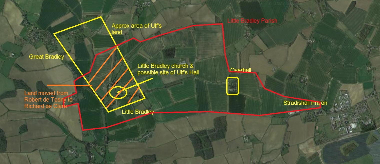
The hall was originally called Over Hall (Over means ‘Bigger’ and the current building is now called Norley Moat and is an Airbnb) and was built on the land Richard had been given. As Ulf’s hall and lands, including the church, had been given to Robert de Tosny it meant that the de Clare’s new hall and the land around it did not have a church associated with it. His land in the Thurlows did - because the churches there existed at the time of the Domesday Book. So it is possible that Richard de Clare wanted a church to go with his new hall and that by land-swap, purchase or seizure that part of Ulf’s former land containing the church was transferred from de Robert de Tosny to de Clare.
No record have yet been discovered to explain exactly what happened but, as the rest of Ulf’s former land remained with de Tosny, a new church, and probably a hall, would then have been built in present day Great Bradley and thus two ‘manors’ with separate halls and churches were created – Great and Little Bradley. The map tries to give an idea of the land involved.
We know that the split had happened by 1174 because there are charters from this period that refer to Little Bradley, but it was probably earlier because sometime between 1100 & 1150 two men are recorded as giving their rights in Little Bradley to the priory in Stoke-by-Clare. If these dates are used, the split happened some 30 - 80 years after the Normans took over land in the area.
Latin would have been the formal language used and the two villages would have been known as Bradley Magna (Great) and Bradley Parva (Little). The use of Bradley Magna persisted as the name of the village on maps until the 19th Century.
Richard de Tosny’s land in Great Bradley soon passed to the Bigods, a powerful Norman family who built Framlingham Castle, through the marriage of his daughter Alice, who had inherited the manor of Great Bradley. She married Roger Bigod (or Bigot, died 1107) who had six lordships in Essex, 117 in Suffolk and 187 in Norfolk. Their son would become the 1st Earl of Norfolk.
The de Tosnys or the Bigods would therefore have been the ones responsible for the building of the first church for Great Bradley, which was begun in the early 12th century (1100s).
